Real-time vessel alerts feature
Real Time Alerts: Instant Updates on Vessel Position, Speed, Course, Arrival, and DepartureNew
Try it out
Container tracking feature
Container Tracking: Track where your container is — see its latest location in real time.New
Try it out

Track any
Vessel, Anywhere!

Stay ahead of the waves!

Try for free
Decorative shooting star animation
Earth view from space — MarineRadar live vessel tracking

112,000+

Vessels

120+

Countries

7,900+

Ports

7,300+

Light houses

MarineRadar app on mobile showing live vessel tracking

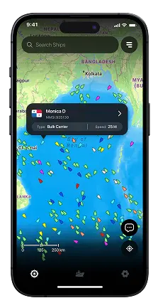
Every Vessel, Every Move

Tap into live ship data — names, types, routes, destinations, and full history at your fingertips.

Vessel information iconVessel Info

VLORA

Albania

ATD

1:37 PM

7 Jun, 2025

MARJ

Egypt

ETA

9:45 PM

21 Jul, 2025

Ship icon
Vessel Type
Aerial view of a container ship at sea

Monica D

CALL SIGN

PANAMA

FLAG

Offline maps icon

Offline Maps

Stay on course even without internet

Satellite view of ocean with vessel tracking overlay
Satellite-Powered
Accuracy
Never miss a vessel, even
in remote seas

Past route playbacks

View your ship's full path, port to port

Ship route path between ports

Vlora

Catanzaro

Malta

Marj

Lighthouse iconLight House
Map showing lighthouse location

7759 NM, 246°

Active
STATUS
70 m
FOCAL HEIGHT
20 sec
FLASH INTERVAL
White
COLOUR
18NM
LIGHT RANGE
2 FPC
NUMBER OF FLASHES
Port iconPort Info
Map showing port location

7759 NM, 246°

3,500 acrPORT SIZE
350 metersMAX LENGTH
200,000 MTFLASH INTERVAL
15 mMAX DRAUGHT
Search by CoordinatesPinpoint any location with exact accuracy
Maritime map showing fleet positions

Monica D

Bulk Carrier

Asia Evergreen

Tanker

⁠Track Fleets SeamlesslyMonitor multiple ships
in one view
Dark & Light ModesSwitch themes for day or night sailing
Dark mode theme icon
Light mode theme icon
Container ship at port — real-time container tracking
Track your containerTrack where your container is and see its latest location in real time.
MarineRadar real-time vessel notification on mobile
Instant Updates onVessel Position
Speed
Course
Arrival
Departure

What our users are saying

Hear from our marine enthusiasts about how MarineRadar has enhanced their navigation and delivered real-time insights at sea.

This app is very good. I didn't know that it was possible to view almost in real time all these movements of vessels around the world. I think it is very feasible to pay for a subscription.
Takashi Murakami profile photo

Takashi Murakami

This marine tracking app is a must-have for anyone involved in navigation or vessel management! With an intuitive interface and advanced features, it allows you to monitor vessel locations, navigation routes, and sea conditions in real time.
Heric da paz Buque profile photo

Heric da paz Buque

It works perfectly, you can easily track ships with AIS coverage, you can access detailed information about a ship, from its ETA, destination, etc., this tracker will definitely be very useful for many people.
Adrian Alfredo profile photo

Adrian Alfredo

Absolutely fantastic app for marine tracking! The real-time data is highly accurate, and the detailed vessel information makes it perfect for both enthusiasts and professionals. Easy to use, reliable, and incredibly helpful for tracking ships worldwide - highly recommended!
Sagarika G S profile photo

Sagarika G S

If you are involved in marine activities like me then MarineRadar is definitely the way to go and what I really like about the platform is their fleet and the subscriptions are a very reasonable and affordable price. Its amazing
Gervásio Campos Man Joja profile photo

Gervásio Campos Man Joja

I am really enjoying following the handful of cruise liner we might want to travel on. The few bugs I have noticed have been fixed and app is improved of all times. I also Like cruise 🚢 variations in this app. This is very helpful app
Faizan Tahir profile photo

Faizan Tahir

Frequently asked questions

Quick guidance to understand how our tracking and plans work.

How does MarineRadar detect nearby ships?
MarineRadar collects AIS, radar, and satellite signals from vessels within range, displaying them on a live map.
Can I see vessels near any port or country?
Yes, you can view ships near your location or search for any port or region globally.
Can I track specific vessels in my area?
Yes. You can search for ships using their IMO, MMSI, or name and view them if they're within range.
Can MarineRadar track ships without IMO numbers?
Yes, the app can also track vessels using MMSI, call sign, or ship name.
What is the main difference between Terrestrial and Satellite AIS?
Terrestrial AIS utilizes land-based receivers, whereas satellite AIS employs satellites to capture vessel signals worldwide.
Which AIS tracking system is more accurate?
Terrestrial AIS provides more frequent updates near the coast, while satellite AIS offers global tracking even when vessels are far offshore.
Does MarineRadar use both AIS types?
Yes. MarineRadar utilizes a hybrid system that combines terrestrial AIS and satellite AIS for comprehensive global visibility.
Can Satellite AIS track a ship anywhere?
Yes. Satellite AIS covers all oceans, including remote routes that extend beyond the range of terrestrial receivers.
Join 50,000+

Maritime professionals already using
MarineRadar

Download on Google Play
Download on App Store
Get the app
Ship illustration with vessel details

Monica D

MMSi:925130

Type: Bulk Carrier
Speed: 25 Kt